1. Introduction to Housing Quality and Dynamics Through Students’ Accommodation
This paper is framed in doctoral research about ordinary housing quality, with special attention paid to the case of blocks of flats (apartments). Literature has used the term ordinary housing to describe those places where a person usually lives and, in this approach, the term highlights its abundance and focusses on a series of shared patterns that would allow research to deal with this built heritage using advanced techniques, taking advantage of their repetitive patterns. Blocks of flats are the main residential typology in many cities and include rented housing, some of which is occupied by students. These self-contained housing units are private, so collecting information is complex and intrusive. Although it is essential to ensure the quality of people’s flats, an efficient method to collect the necessary information about private housing units is unknown.
In cities with a large university community, students live in their parents’ houses, in halls of residence, or rented shared flats. A Coruña (Galicia) is the home of the Universidade da Coruña, which has more than 17,000 students and is a city without public university residences. Therefore, it is common for students to live in rented apartments, which have very different conditions according to the students’ purchasing power, economic effort, contacts, and the supply and dynamics in the property market. For these reasons, undergraduate students’ housing can describe the highly varied situations of other groups in society and its study can contribute to the understanding of the built environment in general. In addition, students demand short-term rentals and many obtain poor housing conditions, which can illustrate problematic dynamics in the city. Nevertheless, students with greater purchasing power and/or economic effort occupy good locations in the city and contribute to real estate speculation (French et al., 2018).
Regarding the social approach, previous research in A Coruña found a correlation between housing dynamics and the sociology of their inhabitants (Rodríguez-Barcón, 2016, 2020) and the same hypothesis for the case of the student population needs attention. Students are in social transition (towards their position in society) and during their studies their social position is derived from their family’s position, according to in Spain (Barañano & Finkel, 2010) and abroad (Almeida et al., 1988; François & Poupeau, 2009), so the students who rent a flat also represent a wide range of social situations. In addition, due to the precarious conditions of some students and their temporary situation, undergraduate students tend to respond to questions about their housing conditions without prejudice. Students’ family houses also reflect the different housing situations in society, taking into account the existence of underrepresented groups in the university system (Barañano & Finkel, 2010). Thus, the student population exemplifies many variable housing situations (Abubakar Ghani et al., 2018; Alamel, 2020) and describes different social groups with their capacities – sociological capitals (Lamela, 2014; Pereira, 2018). These studies about groups and the social aspects of housing normally use anonymous questionnaires (Almeida et al., 1988; François & Poupeau, 2009) on the one hand, and/or personal interviews and visits to the buildings on the other (Abubakar Ghani et al., 2018), resulting in a lack of detail in the former case and being quite invasive in the latter.
The environmental approach focuses on the characteristics and indoor quality of the building. This approach suggests that the building must provide quality in terms of health and well-being to its inhabitants, beyond solving minimum needs. Edward White (1989) and Pinson (1993) contributed to this theory through the Post-Occupancy Evaluation that sought to know the real use of the building and the users’ perceptions. Pinson pointed out the need to understand this approach in ‘trivial’ buildings, in contrast to some methods instituted in the architectural avant-garde, a critical position also shared by sociologists like Léger (2010). For this reason, this research focuses on the quality of the ordinary blocks of flats according to the advantages they offer to their inhabitants and can be divided into the material quality and cultural-symbolic quality, as explained and applied in previous work (Pereira-Martínez, Borges Pereira, et al., 2020)[1]. This approach to quality in ordinary buildings differs partially from others used in the analysis of artistic works, such as the Baukultur (Davos Declaration, 2018) or the three Vitruvian qualities. Nevertheless, the aforementioned analysis matrix allows the study of ordinary quality as a two-dimensional field[2] and has the potential to reveal the correlations between residences’ quality and users’ social status (Pereira, 2018), which is one of the purposes of the data collection. These environmental methods that analyse built spaces and people’s reactions require detailed drawing and interviewing work (Léger, 2010; Pinson, 1993) and it is difficult to find a relationship between the studied buildings and others with the results of the cases are not repetitive.
Finally, the spatial approach to the phenomenon deals with the geographical distribution of student residences and their origins. On the one hand, the residences’ locations help researchers to understand the dynamics between territorial interest and building quality since it is difficult to access a good combination in an affordable flat (Dang et al., 2014). Good accommodation in a peripheral area has a different value and provides different conditions for a student compared to one in the city centre. In the previous work (Pereira-Martínez, Borges Pereira, et al., 2020), the existence of geographical, economic, and social peripheries was shown based on buildings’ qualities, and these features were related to users’ capitals. On the other hand, different geographical origins (i.e. rural vs. urban areas) could affect the students’ choice and their opinion about their accommodation (Rodríguez-Barcón, 2016). In spatial studies, obtaining a precise location that can be related to specific housing units is problematic and they usually work on a wider scale using areas (districts, neighbourhoods), thus it is difficult to integrate with the information on a building scale. Nevertheless, some studies were able to relate spatial and building information in individual cases (Alamel, 2020) and this approach has great potential to explore.
Despite the existence of the aforementioned studies, there is still a gap in the literature to cover a global vision of these three aspects (interdisciplinarity) and consequently to allow them to be correlated. In addition, a less intrusive workflow is sought, friendlier to people and that can be applied in any housing building or urban area. The case of the undergraduate students’ housing is highly representative of other cases due to the aforementioned social, environmental, and spatial reasons. The theoretical framework explained in this introduction lays the foundations for the following sections about the necessity of a geo-data collection strategy and the specific design of the strategy developed for this case, including an example of its preliminary results using the pilot group of the survey.
2. Necessity and Requirements for a Geo-data Collection Strategy
The multifaceted analysis necessary to study this complex reality requires a strategy to collect many different types of sensitive information in a less-intrusive and efficient way:
-
First, the social approach presents parameters related to the economic and cultural capitals of the students’ families and other social-demographic data (age, gender).
-
Then, the environmental analysis requires a description and students’ opinions about the buildings, housing units, bedrooms, and neighbourhood features.
-
Finally, the spatial approach needs the location of the accommodation and the geographical origin of the student.
The amount and different types of data required for this survey threaten its feasibility, integrity, sample size, and the privacy of the studied specimens. This would be the case if a microanalysis were performed, like in Post-Occupancy Evaluations (Léger, 2010; Pinson, 1993). The methods of asking the students to draw their bedrooms/accommodations or personal visits are discarded, due to the lack of standardisation of the former and the effort and intrusiveness of the latter (particularly during the Covid-19 pandemic). Other macro and urban techniques would be too general for this study. Therefore, an efficient strategy to collect a large amount of sensitive and graphic information is proposed, because there is a lack of use of medium (neither micro nor macro) techniques in architecture. In addition, in the case of ordinary blocks of flats, it is possible to take advantage of their cultural spatial model and common repetitive patterns[3], which allow the use of non-intrusive and technological techniques. Thus, the strategy to collect information, which is developed in the following section, even if it collects valid information for the students at home and in halls of residence.
3. Design of the Information Collection Strategy and the Tools of the Survey
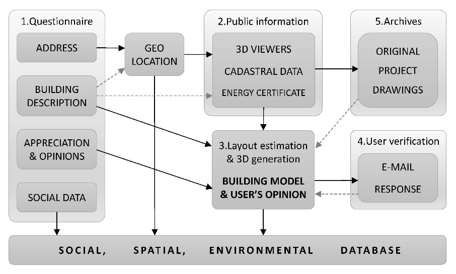
Thus, the survey proposes a strategy that uses several sources of information (a questionnaire, public services, individual verification, and consultation in archives) and advanced techniques (GIS, non-intrusive internal estimation, automated 3D generation, and probabilistic methods) to be efficient and user-friendly to reduce student inquiries. Figure 1 relates the sources and steps for obtaining information with the three aspects under investigation.
__and_ma.jpeg)
Firstly, a short questionnaire asks about the data that it is not possible to obtain through other means: building characterisation, appraisals, social origin, images, addresses, and contact. This requires the processing of private information and the anonymisation of results in a second step. Nevertheless, with the address, the researcher can geo-locate the building, study the external configuration, access public information, estimate the internal configuration (Pereira-Martínez, Lameira, et al., 2020; Yue et al., 2012), and consult information n in archives. The procedure of requesting the address (Alamel, 2020) could be controversial and pose risks – fewer or lower quality responses –, but, if it is clearly explained, students do not mind giving information about this if those are in their favour. The following epigraphs describe each part of the strategy and open up to a general discussion about data collection and processing.
3.1. Questionnaire
The questionnaire is a traditional tool to study social groups (Almeida et al., 1988; Pereira, 2018) and this instrument should balance extension, clarity, depth, and intrusiveness. In this research, the design includes two main constructs: the student’s accommodation and the social status of the family.
In the first section, there is the question about the address, a Likert scale (1-7) to assess their satisfaction with and the quality of the flat and the room (comfort, light, aesthetics, furniture, equipment, views, etc.), and finally, multiple-choices and writing space to describe the building features. Examples are included to obtain more homogenous responses about the address and other issues. Additionally, the student is invited to share photographs of the flat/room. In another section, the questionnaire is comprised of sociodemographic items (age, gender, geographical origin) and questions about the parents, to know their social status. For this, multiple-choice questions include information about their housing tenancy and job situation (partial indicators of economic capital) and their level of studies (part of their cultural capital). Moreover, students are invited to give the full address of their family, to compare their accommodation in A Coruña and their family house.
The questionnaire is designed to be applied online during class time and to be completed integrally, but students can indicate the non-applicability of certain questions or their refusal to answer. The questionnaire was validated by several methods: a verification by the Research Ethical Committee of the PhD program in the University of A Coruña, an external validation by experts (architects and sociologists), a focus group of professors and students, and finally, by the internal coherence of data. The questionnaire was also tested with a pilot group in a class of 10 second-year architecture students. This served to prove the feasibility of the strategy and produced the examples shown in the figures.
3.2. Public Information (Cartographic Viewers, Cadastre, and Energy Certificates)
The address that the students provide allows access to the public information about the building, as shown in the left section of Figure 2. This is theoretically simple, but its implementation implies some practical problems in contemporary research that should be discussed. In this case, the questionnaire requests a non-structured address from the respondent (following an example) because it is the most user-friendly method: there are problems with structured address collectors (especially in rural areas and foreign countries) and integration difficulties in web services (in this case, Microsoft Forms).

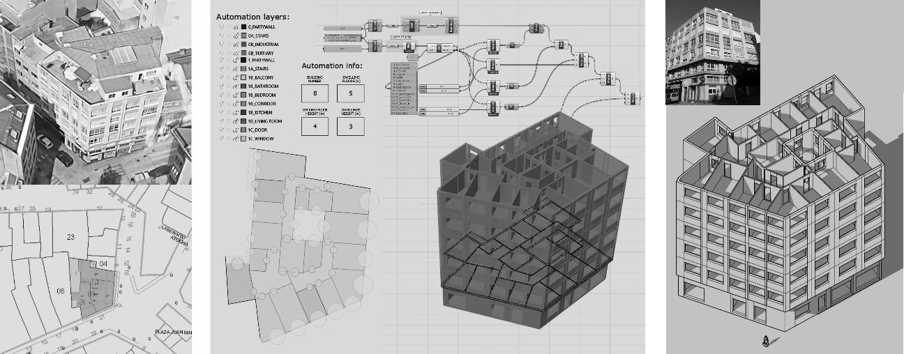
The address is verified on GoogleMaps and the coordinates are identified, as well as for the responses that only name the street or neighbourhood, which allow an approximate geographical location. Search engines are especially adequate for non-structured information, but addresses must be introduced manually; therefore, improvements in address processing could be very profitable, especially if carried out by public services (i.e. cadastral and post addresses). Then, the geo-location of both student and family residences are manually typed to create the multi-type database with the alphanumerical information and files (photographs). Automatic routines can use the GIS coordinates to add orthophotos and oblique views of every building to the database.
The address is also related to the cadastral reference to access detailed information manually, such as the CAD/GIS external shape, façade photo and horizontal division drawings. In addition, alphanumerical data can be automatically downloaded, such as the construction date, the number of floors, the typology, the number and area of residences, and the areas dedicated to different uses.
Energy consumption and emissions certificates are mandatory for rented flats and then available using the address. This would allow researchers to assess the housing units and verify this information with the user’s description, but more detailed data would be preferable, and some students’ flats are rented in a precarious situation without a certificate. The energy certificates are checked manually because, despite bulk downloading being previewed in Galicia, it is only available for the most recent cases and, once again, addresses structures are not standardised.
In the previous explanation, the manual and automatic tasks are emphasised to highlight the difficulties, current advances, and potentials found in this case for an integrated, non-intrusive workflow in architecture and urban studies. On the one hand, descriptive technologies – raster, orthophotos, viewers, photogrammetry including Google Earth 3D – are useful to manually consult information; nevertheless, their integration in an efficient workflow is difficult and/or complex. On the other hand, vector easy-link spatial information – such as CAD, BIM, GIS, and simplified BIM (Jabi, 2016) – could have the biggest potential to be included in an integrated, efficient workflow. An example of this is the Spanish Cadastre with normalised exterior drawings and indoor information in vector interoperable formats (but variable in quality, detail, and reliability) which are used in the following section to develop layout estimations that are linkable to the database and communicative for the students.
3.3. Methods of Layout Estimation and 3D Generation in an Integrated, Efficient Workflow
The estimation techniques are useful for blocks of flats in this context because their housing units follow a repetitive model: an internal layout highly determined by the outer perimeter, restrictive common patterns, and a predefined spatial model (Pereira-Martínez, Lameira, et al., 2020). They are adequate for the case of the students’ flats but do not work for cases not limited by their external configuration, such as the detached houses of the students’ families, with many spatial possibilities and different typologies.
A previous paper[4] designed a shape grammar methodology to estimate the positions of the main rooms (kitchens, living rooms, and bedrooms) and the common stairs. In this study, the methodology was manually applied and complemented with the strategy developed by Yue, Krishnamurti, Grobler (2012) that estimates the internal layout based on windows and roof information (kitchen extraction and bathrooms/toilet air exhaust pipes). Figure 2 displays the application of these techniques using the vector perimeter and the descriptive information (left section), to form a simple 2D scheme (middle-left), able to be automatically processed to build a detailed thickness-included 3D model (middle-right). The estimations of the main and ground floor are drawn in CAD using the notion of lightBIM – focussed on spaces and spatial relations (Jabi, 2016) –, with polygons for spaces (without wall thickness) and circles (representing points) for doors/windows. A certain layer structure and template allows its automatic processing by GIS (ArcGIS) and by parametric 3D modellers (GrassHopper-AutoCAD-SketchUp) to form a 3D model for analysis and respondent verification.
According to the verification of the following sections (users’ feedback and drawings in archives), there is a quite high level of accuracy in the number, position, size, and even shape of the main rooms – especially high for kitchens and living rooms. There are sometimes differences with bedrooms, mainly if they are precarious (without windows). There is less accuracy in secondary spaces –corridors, bathrooms, storage spaces, etc, especially if they are internal and have no façade – and the shape of spaces often differs. There is then a variable but controlled uncertainty, which is considered.
Layout generation and automatic 3D modelling is also a field of research in progress which has made great development in recent years (Guo & Li, 2017; Keshavarzi & Rahmani-Asl, 2021; Merrel et al., 2010; Silva et al., 2015; Yue et al., 2012) and has potential for the future, including its integration in BIM workflow. It is necessary to highlight that the proposed estimation methodology and software application (Pereira-Martínez, Lameira, et al., 2020) can process both orthogonal and irregular layouts (Figure 2), necessary to apply these methods to reality, and this constitutes a great asset in comparison with other studies, based on and limited to Cartesian geometry. This application illustrates the potential of formal methods to advance in an efficient, integrated workflow because they work with geometry and structured data. These possibilities will increase with probable improvements in vector information (cadastre) and new AI techniques for window recognition and 3D location on façades. Nevertheless, some integration problems remain or can appear between different software and these issues multiply the work of professionals and researchers.
3.4. Verification of the Building Information with Users
The questionnaire obtains respondents’ e-mail addresses to verify the previous public information and layout estimations. To do this, the respondents received a standardised e-mail explaining the aims and procedures of the study with the alphanumerical data obtained (construction date, description, etc), graphic information consisting of the public cadastre photo, and, if applicable and in the case of architecture students, the files of the simplified CAD layout and the 3D model (middle and right part of Figure 2).
Thus, it is possible to verify non-intrusively with respondents if the address and the building are correct, the internal configuration is accurate (or what the errors are), and receive more information from students: descriptions or even files, because the architecture students can modify the drawings and models. It is only a minority of students who respond to this second step, but their feedback is qualitatively very valuable to verify the accuracy of the information and the methods. This non-intrusive strategy of a short questionnaire with a second statistical verification has the advantage of normalising database information and reducing respondents’ efforts.
3.5. Verification with Historical Archives
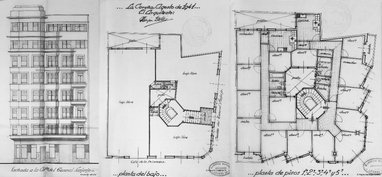
A second verification is based on the historical archives in the municipality of A Coruña, which gathered building projects and construction licenses until the 1970s. This is adequate for this research because student flats are usually old (Figure 3) and in these cases, the Spanish Cadastre is less complete and reliable. This second method of verification reduces uncertainty due to the lack of responses by e-mail, gives good material for comparison, and adds more information about the buildings’ designs and quality. Some buildings’ projects are not found and others could have been transformed during construction or been renovated, so all the cases are studied with a certain level of uncertainty.

This building in Figure 3 is an example of an old building occupied by students. It was designed for the middle class with similar repetitive bedrooms and spaces, which are precisely what students normally seek in their accommodation. The shape and geometry are complex, following the design trends of a bourgeois building from the ‘40s with a carefully designed façade, but the spatial order and patterns are simple and repetitive, following the ordinary model described in previous research (Pereira-Martínez, Lameira, et al., 2020). The fact that examples like this can become obsolete for the original target population and be occupied by students illustrates the complexity of building dynamics and the potential of students’ flats analyses to unveil them.
3.6. Integration in a Social, Spatial, Environmental Database
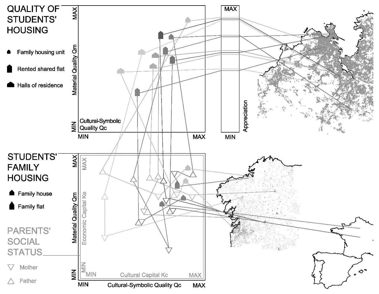
The data from the previous sections are integrated into a multi-type geo-database that allows researchers to analyse detailed dynamics in complex phenomena, like the case of undergraduate students’ housing. The social, spatial, and quality implications of the accommodations are analysed, taking into account the variability of users’ appraisals, also included in the database. Thus, this analysis can interrelate the results of each specimen in the different aspects, using the analytical fields presented in this case: student’s housing location, appreciation, accommodation’s quality, parents’ social status, parents’ house quality, and student’s geographical origin. An example of the database information in these analytical fields is shown in Figure 4 using the results of the pilot group (10 specimens) in the form of a graph.

On the left, the quality of the students’ accommodation, family residences, and their parents’ social status are interrelated; in the middle, the students’ appreciation is shown; and on the right, the locations of the students’ homes in the city (upper picture) and their geographical origin (lower picture) are arranged. The housing geolocation and student origin are related to the characteristics of the buildings and social data on the left. This graph provides an overview of the study and the database with the three-factor approach: social, environmental, and spatial. Preliminary quality and capital synthetic indices were used for this representation and are still under development and validation. Under these reservations, Figure 4 illustrates the variability and differences in housing qualities (generally lower in student shared flats than in family homes, but not always) and possible correlations between the individual variables or the general position in each field of analysis. Furthermore, this can be used as a basis for many other questions and hypotheses.
This survey is in progress and the growing sample is not easy to represent and analyse individually at this level of detail; nevertheless, these examples serve to understand the procedures and expected type of results of this data collection strategy and the eventual analyses that can be applied to the database.
4. Discussion of the Students’ Housing Case and the Data Collection Strategy
After explaining the strategy design, the procedures, and the type of data collected in the previous sections, the case of students’ housing can be better understood in its heterogeneity and the complexity of the dynamics involved. An example of this is Figure 4. The complexity of these analyses needs to be explained in future dissemination, but the case of A Coruña illustrates the variability of the conditions of their undergraduate student housing and the complex phenomena involved.
The discussion about the necessity of a data collection strategy and its specific design should consider the different aspects of the problem, the phenomenon characteristics, and the available sources of information, as explained in the introduction. The adequacy of the strategy to the group of informers is a key factor in this study as, undergraduate students were especially targeted groups for their greater accessibility, openness, and capacity to represent other housing dynamics. Thus, an advanced collection of data could be implemented. It would be desirable to introduce more detailed information and techniques in further studies about the subject and apply typestyle of strategies – with the necessary adaptations – in other groups and the general population.
Regarding the data collection strategy, in previous sections, certain methods and tools were specifically discussed regarding their advantages and disadvantages, but the underlying topics are the new advances and possibilities offered and how to integrate them into an efficient workflow in architecture and urban studies. This integration is still unclear and depends on the public services and software developers’ strategies. This research is an attempt to introduce and apply some of these possibilities in a geo-data collection strategy and deals with several sources of uncertainty. This strategy allows the researchers to confirm a complex, alphanumerical and spatial, normalised database with comparatively less effort and intrusion than other similar surveys, with the maximum depth of parameters and a variable controlled uncertainty. Nevertheless, there is still great room for improvement, as commented, based on improvements in the interrelation of data, access to public data, and the new techniques for processing this information.
This paper brings to light several issues with contemporary research in architecture: the need to advance in more comprehensive surveys, leveraging technology with more automation, respecting privacy, being less intrusive and maintaining enough depth. Some of the terms are contradictory, so the study of the difficulties, possible balances, and the strategies to face them are intended to be contributions of this manuscript.
5. Conclusions and Next Steps in the Research
This paper shows an original approach to the collection of different types of data, taking advantage of an accessible and participative group – undergraduate students –, the latest technologies, access databases and information, and the notion of the underlying shared parameters of ordinary buildings.
This strategy to collect information has brought to light remarkable efficacy and utility. Some methods can be used to decrease respondents’ effort and boost their participation, and others to minimise research work and obtain normalised data. Researchers can take advantage of powerful, accessible databases and new technologies and insights. Less-intrusive methods introduce a variable uncertainty that must be considered. This survey takes advantage of several advances in terms of efficiency, and some improvements are proposed, but many problems remain in terms of data collection and processing before obtaining an expected, integrated, non-intrusive workflow.
Regarding the students’ housing quality, different levels and standards were seen, especially when students’ flats and families’ residences are compared. The relationships between the residences’ qualities and other parameters (social origin, position within the city, price, age, geographic origin, etc.) are rather complex and can be affected by social attitudes, subjective appreciations based on these parameters, and the survey’s internal uncertainty. Partial correlations would be found following this strategy between the housing’s material quality and users’ economic parameters if the results confirmed the lines of research pointed out by the preliminary results of the pilot group.
The normalised multi-type database obtained is a good asset for the next steps of the research, which are:
-
correlations and multi-factorial analyses of students’ variables and satisfaction, with spatial/graph representations;
-
advances in automatic modelling, integration GIS-BIM, and quality assessment for ordinary buildings;
-
an in-depth study of quality, developing a synthetic index to relate building qualities to users’ capitals.
Acknowledgements
The authors thank the participants in the focus group who helped to validate the questionnaire (Carmen Lamela, Jorge Rodríguez, Hilda Cuba, Andrés Fernández-Albalat, Pablo Fernández, Noelia Vázquez) and Professor Manuel Docampo as an advisor in its development. A special acknowledgement should be made of the Municipal Archive of A Coruña, Emma Sankey for her support and orthographic review, professors who allowed the questionnaire to be answered in class, and of course of the students participants in the survey, with their careful answers and interesting appraisals. Finally, the inspiration for this study should be found in the historical claims of several generations of students in A Coruña about their housing conditions and their struggle to get public halls of residence.
A complete study of these quality components was carried out in a previous article (Pereira-Martínez, Borges Pereira, et al., 2020). The quality of housing buildings can be subdivided into their material quality, cultural-symbolic quality, and centrality (location). These features can be related through Bourdieu’s distinction with the economic, cultural, symbolic and social types of capitals of their inhabitants (Pereira, 2018).
The notion of positions (levels of quality) and vectors (requalification, improvement of qualities) can be used in this quality field, with the advantages of these methodological tools for analysis, comparison, and projections.
In the context of the ongoing thesis, a previous paper studied the spatial model and common patterns in ordinary blocks of flats in Porto, Portugal (Pereira-Martínez, Lameira, et al., 2020). A shape grammar for the general configuration of these buildings was developed, programmed, validated, and prepared for a large number of cases. The empirical research of the thesis found the same spatial model in buildings in the city of A Coruña and other municipalities in the Galicia-North Portugal Euroregion Literature and it explains other ordinary patterns in other places – i.e. studies in the USA by Yue, Krishnamurti, Grobler (2012) – that would invalidate the notion of a ‘generic’ model applicable anywhere. This understanding of the spatial model of this cultural-technical context allows the use of non-intrusive methods, reducing detailed manual analysis, which is an interesting and necessary line of research in architecture.
A study of ordinary spatial patterns in ordinary blocks of flats was done in Pereira-Martínez, Borges Pereira, et al. (2020). A shape grammar was developed for estimating the position of rooms of a certain size in contact with the façade and the possible position of the common stairs at the centre of gravity of the rest of the floor.